

Mahoosuc Highlands Initiative Receives Big Boost from New Hampshire’s Land & Community Heritage Investment Program
- Tags:
- Land Conservation,
- Climate
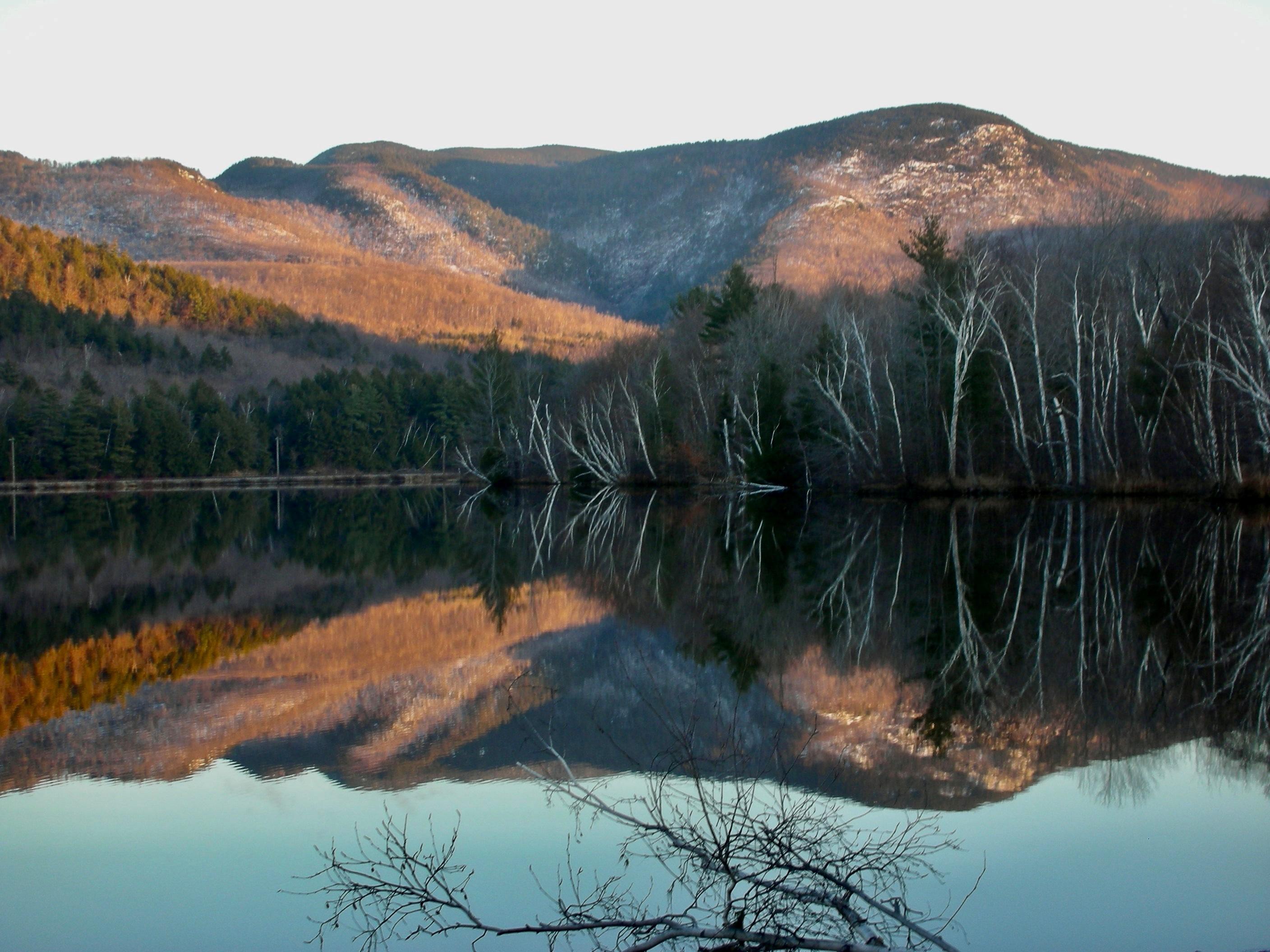
The project is visible from the Appalachian Trail along the Presidential range summits of Mt. Adams and Mt. Madison, and Mt. Moriah. The project offers a protective buffer on both sides of the Trail for 2.6 miles. (Photo: Kate Stuart)
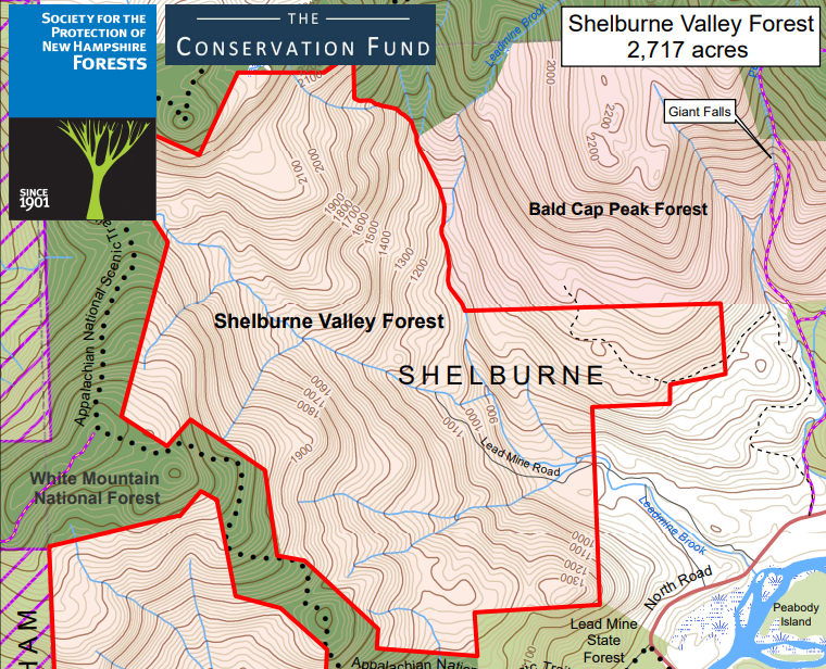
The Society for the Protection of New Hampshire Forests (Forest Society) is working towards the permanent protection of the 2,717-acre Shelburne Valley Forest, which stretches from the shoreline of the Androscoggin River to the ridgeline of the Mahoosuc Range. Today, the New Hampshire Land & Community Heritage Investment Program (LCHIP), which is celebrating its 20th round of grant awards this year, announced a $500,000 LCHIP grant to help the Forest Society conserve the land.
The property is part of a larger Mahoosuc Highlands Initiative protecting the Shelburne Valley and Bald Cap Peak Forests. Rising from the valley floor of the Androscoggin River and reaching the narrow spine of the Appalachian Trail, the Shelburne Valley and Bald Cap Peak Forests present spectacular views to travelers along Route 2 in Shelburne, a view that exemplifies the rugged beauty of New Hampshire’s North Country. Building on decades of collaborative conservation efforts to protect a connective corridor of unfragmented forest in the Upper Androscoggin Valley, the Forest Society and The Conservation Fund (TCF) are now working together on the two adjacent projects, which includes the 2,717-acre Shelburne Valley Forest and the 1,030-acre Bald Cap Peak Forest.
The Forest Society’s $500,000 LCHIP grant will help permanently protect the Shelburne Valley Forest. The property is home to diverse riverine habitats, including cranberry bogs, red spruce swamps, silver maple floodplain forests, as well as talus slopes and cliffs. A local recreational resource, the project includes the Cross NH Adventure Trail (an increasingly popular 84-mi bike-packing trail that traverses northern NH), 1.6 miles of frontage on the Androscoggin River for fishing and boating, and provides a protective buffer for the Appalachian Trail (AT).
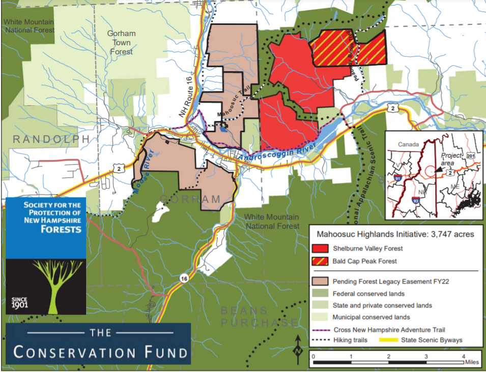
The combined project will result in more than 3,700 acres being conserved. Both properties will eventually be owned by the Forest Society as a permanently protected forest reservation. The lands will be managed for their long-term, multiple use objectives, including forest management, habitat protection, scenic value, and for public recreation and education. The lands will remain open to hiking, hunting, fishing and for future forest management.
“The proposed projects epitomize the Forest Society’s goal of conserving lands that contribute to interconnected, biologically diverse ecosystems that combat climate change, protect water quality, provide forest products, and enhance outdoor recreational opportunities,” states Jack Savage, president of the Society for the Protection of New Hampshire Forests. “We look forward to working with our partners, The Conservation Fund and the Shelburne Conservation Commission, to ensure the public access to these lands and that the resources are managed carefully for generations to come.”
The Mahoosuc Highlands Initiative will take place in two phases, with the first phase (2021-2023) encompassing the purchase of the 2,717-acre Shelburne Valley Forest from a timber investment management company by the Forest Society with assistance from TCF and the Shelburne Conservation Commission.
The more than 1.6 miles of shoreline along the Androscoggin River hosts exemplary state-significant silver maple floodplain forests and the uplands contain cranberry bogs, red spruce swamps and other riverine habitats. Higher elevations are home to black bears, with talus slopes and cliffs for denning, and extensive mast production for food. In addition to protecting a carbon-rich forest, the project’s extraordinary expanse from valley floor to a North-South ridgeline provides habitat connectivity across elevational and longitudinal gradients, allowing species to better adapt to a changing climate.
Containing 24.3 miles of stream frontage and the headwaters of the Leadmine Brook, the project supports critical cold water stream habitats for native brook trout, a NH Species of Greatest Conservation Need. The project aligns with the Shelburne Master Plan adopted in 2016 and mutually supports the Shelburne Conservation Commission’s efforts to protect and conserve the Androscoggin River and forested uplands and contributes to a long-standing successful conservation effort in the region.
Current recreational uses of the property include hunting, biking, walking, and access to the Androscoggin River for paddlers and anglers. A diverse recreational resource for the region, the project includes the Cross NH Adventure Trail, 1.6 miles of frontage on the Androscoggin River for fishing and boating including a popular launching site for fishing guides.
“The Shelburne Valley Forest will protect a significant ecological, economic, and recreational resource for the region,” states Brian Hotz, vice president of land conservation at the Forest Society. “We are thrilled to be working with the Forest Society and The Conservation Fund to make this happen.”
The second phase will protect Bald Cap Mountain. The Conservation Fund pre-acquired the Bald Cap Mountain Forest at the request of local stakeholders and in cooperation with the National Park Service (NPS). Approximately 300 acres of the original property has been conveyed to the Park Service as part of the Appalachian Trail Corridor. The remaining 1,030-acre property is included in The Conservation Fund’s FY2022 Androscoggin Valley Corridor Forest Legacy Project. As a result, the Forest Society will eventually acquire the 1,030-acre property from TCF subject to a Forest Legacy Easement held by the State of New Hampshire.
“Together, the Shelburne Valley Forest and Bald Cap Mountain projects will conserve more than 3,700 acres of extremely important land in the North Country,” states Dijit Taylor, executive director for the Land & Community Heritage Investment Program. “LCHIP is proud to assist with projects like these that meet longstanding local conservation priorities and offer such an array of resource values.”