


Frequently Asked Questions about the 2024 Project
What’s happening at Mount Major?
On May 13, we began an ambitious trail project to greatly improve the sustainability of Mount Major's Main Trail, the most popular route up and down the mountain.
The Forest Society is teaming up with Town 4 Trails Services and OBP Trailworks to construct a sustainable trail to take the place of about 1/3 mile of the existing Main/Blue Trail. The lower sections of the Main Trail include some extremely eroded sections, the result of steep grades on sub-optimal soil combined with thousands of footfalls annually.
The project was completed on August 26.
Why is it necessary?
For decades, the soil eroding from these areas has been washing down the trail, into streams and directly into Lake Winnipesaukee across Route 11 from the Mt. Major parking area. In addition to being a more enjoyable hiking experience, the new trail section should also require much less maintenance over time. It will also be a major ecological improvement, reducing runoff and silting into Lake Winnipesaukee.
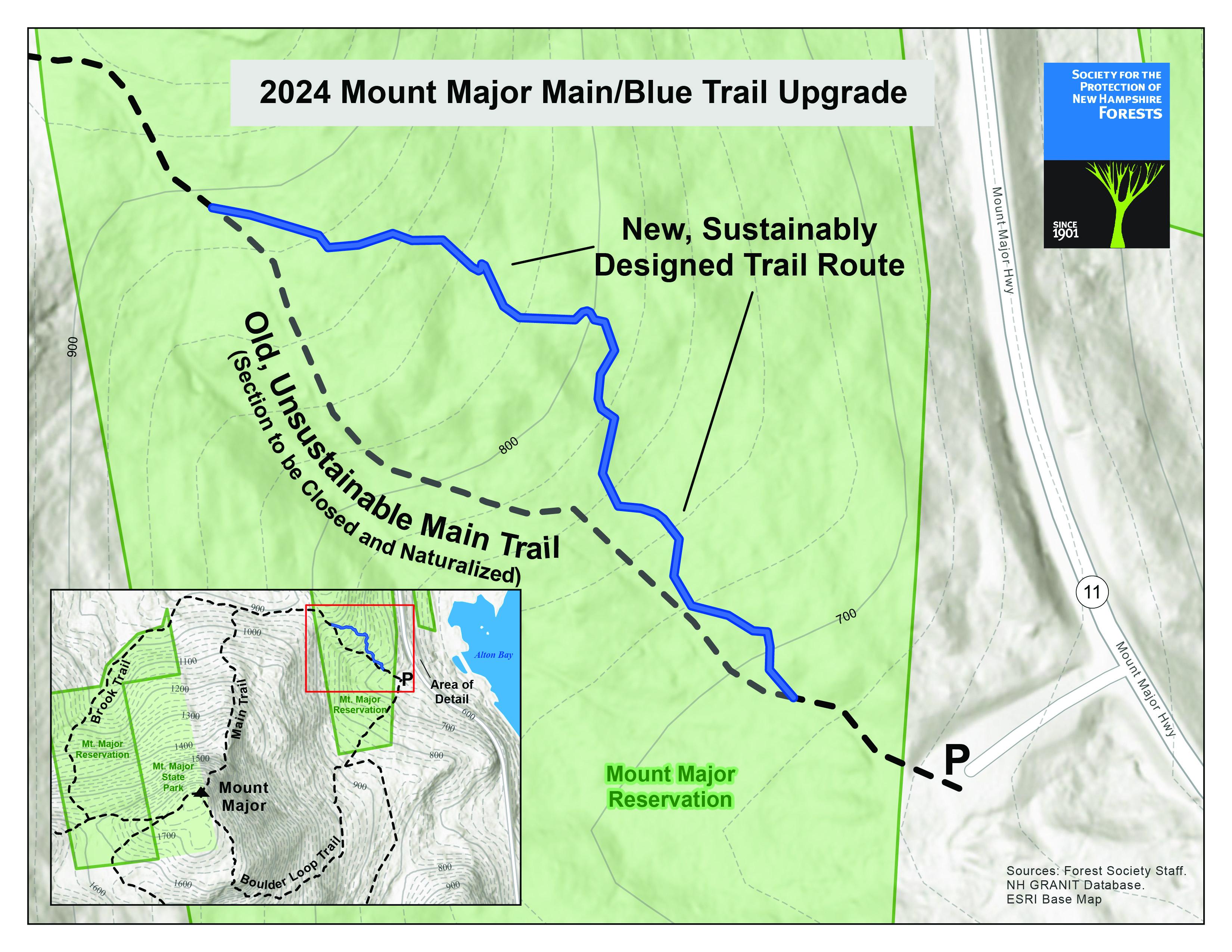
What will be done with the old section of the Main Trail? Why can’t it be repaired?
The old section of the Main Trail will be closed, and restoration work will be done to stabilize and rehabilitate the area, including structures to prevent further erosion, allow drainage, as well as re-seed and encourage regeneration of vegetation to help stabilize the soils.
Why can’t you just fix the erosion on the Main Trail?
The unsustainable alignment of the Main Trail cannot be fixed. The issues it has are very severe, and it would take a massive amount of work to stabilize the trail but would only slow, and not fix, its problems.
But I love the canyon section of the trail — I think it's beautiful!
It may look interesting but it’s not good for humans, wildlife, or the forest. If you want to walk through epic canyons, check out Lost River Gorge & Boulder Caves or The Flume.
Why wasn't the original trail built sustainably?
Many older trails were not built sustainably. Early trails in New England were often sited where they provided the shortest and most convenient route to the summit, with little thought paid to long term impact, often running directly uphill or utilizing old, existing logging roads themselves built for short term use.
A greater understanding of the long-term impacts and issues arising from unsustainable trail construction came as later trail maintainers worked to repair the problems of old trails. At the same time, trail builders have developed a better understanding of how to design trails for long term sustainability.
What are the rock deposits on Mount Major and what is "rotten rock" that you see on the old section of trail?
Good question! According to the White Mountain National Forest: "When this rock was forming millions of years ago it was heated up twice, weakening the bond between minerals in the rock. This weakening allows water, ice, and air to get in-between the minerals and break it apart into little pieces."
You might be interested in this book on the (fascinating) geology of the Belknap Range: Stepping Stones Across New Hampshire: A Geological Story of the Belknap Mountains, by Jay Long.
According to a 1941 publication, The Geology of Winnipesaukee Quadrangle, by Alonzo Quinn: "The Belknap Mountains area shows superb examples of a peculiar type of geological structure known as a 'ring-dike.'" The ring dike has volcanic rock, Conway granite, and older rocks.
"Spectacular exposures of the contact of the Albany quartz syenite and the Meredith porphyritic granite may be seen on the top of Mt. Major and the hill one and a third miles east of Round Pond," Quinn wrote.
See also: Ring-dike Complex of the Belknap Mountains, New Hampshire, by David Modell, published in 1936.
How do you know that this work will make a difference for erosion, drainage, and runoff?
Good design goes a long way. Since those early trails were built, trail workers have learned how to build trails with the landscape rather than against it, aligning the trail with the natural contours of the terrain to facilitate good drainage and prevent erosion issues. Trails climb gradually across slopes rather than directly up them, allowing water to run off of trails instead of down them, minimizing erosion.
In places where the trail must climb directly uphill, structures to control erosion such as stone staircases are built BEFORE erosion problems develop and are built to stabilize the whole area exposed to erosion issues, not just to patch up problems that have developed.
What does "sustainable" trail mean?
Sustainable trails are designed to control the environmental impacts that hikers have on a landscape. They concentrate and minimize the impact of thousands of footfalls, preventing greater harm and degradation to the surrounding landscape.
They are designed to be appropriate for the amount of use that they see, being more developed in areas with heavier use than areas that see more sporadic use. They are designed to minimize maintenance, so that the trail can be kept in good condition with as little cost and effort as possible.
Why do you work with professional trail builders on this type of project?
Pulling off a project of the scale required at Mt. Major necessitates advanced tools and techniques, as well as years of experience in the craft of trail building to construct the trail well and efficiently. Professional trail builders are absolutely necessary in a project of this magnitude.
What are the trail builders doing to make this new section of trail sustainable?
The Mount Major trail crews have chosen a wide, gravel path as the most sustainable and eco-conscious route up the mountain.
The gravel is a mixture of crushed stone and stone dust and when compacted will form a durable surface that will remain resistant to erosion. In places along the trail where rain or flood water drainage is an issue, the crew adds a layer of coarser crushed stone beneath the gravel mix to allow water to filter through the surface of the trail.
Additionally, the team will lay granite slabs to be used as staircase steps in places along the trail that need extra reinforcement against erosion. These stones hold loose or crumbling dirt in place and prevent run off of water and soil from occurring where the trail gets steepest. Plus, it provides consistent staircase which serves as an easier route for hikers, and keeps visitors from leaving the trail.
Are trees being cut down for the new section of trail?
To construct the reroute, a trail corridor needed to be cleared. Crews sought to minimize how many trees were cut whenever possible and performed the cutting work during the winter to lower impact on certain nesting animals, such as bats.
Can I still take the Main Trail during construction?
Yes, except for a detour at the beginning of the trail where construction will be taking place over the next 12 weeks. (See signage on site for marked routes to the summit.)
How did you come up with the number of footfalls per year?
The Forest Society conducted estimates of visitors a few years ago and came up with 80,000 people hiking the mountain. If you multiply 2,000 steps per mile on average x 3 miles (roundtrip) x 80,000 people = 480 million steps annually.
What else is being done to make sure Mount Major will stay beautiful and open for recreation?
In recent years we have constructed a pavilion area and kiosk in the parking lot, reconstructed the main trail entrance to solve drainage issues, and we’ve recruited and trained more volunteers to help orient hikers, especially on busy days (we launched the Volunteer Trailhead Outreach Program in 2022). We also regularly host an Earth Day DIY cleanup on the mountain.
Why is the Forest Society in charge of this project?
Nearly 10 years ago, a coalition of organizations, led by the Forest Society, successfully raised more than $1.6 million to support the acquisition and stewardship of 950 acres and conserve key parcels of land on and surrounding Mt. Major. Since then, the Forest Society has purchased an additional 265 acres on the mountain. The Forest Society manages the property it owns and works with volunteers, and public and private partners to keep trails open and maintained for the public.
What can I do to support this project?
Donate online or at the trailhead.
What else can I do while I’m hiking at Mount Major to help?
Follow the New Hampshire Leave No Trace principles including:
- Know Before You Go
Known before you go means doing your research for safe and fun adventures!
- Stick to Trails
Prevent injury and reduce damage to landscapes by sticking to trails.
- Trash Your Trash
Whether you’re out for a short walk or a weeklong trek, carry out what you carry in.
- Leave it as you Found it
Leave nature where you found it to help preserve NH.
- Keep Wildlife Wild
Leave wildlife wild by observing at a distance, refraining from feeding, and always store food securely.
- Share the Outdoors
Sharing the outdoors means being kind and respectful to everyone you meet in NH’s great outdoors.