
Land Conservation in New Hampshire: A Snapshot of Progress & Opportunities
A Report Prepared for the New Hampshire Legislature’s SB 388 Study Committee October 2014
Executive Summary
This report is offered by the Society for the Protection of NH Forests and The Nature Conservancy with the purpose of providing baseline information on the status of conserved lands in New Hampshire for consideration by the SB 388 Study Committee. In addition to surveying the current state of conserved lands, the report provides a summary of strengths and weaknesses of the present portfolio of conserved lands and identifies opportunities and priorities for future land conservation.
Highlights of Findings
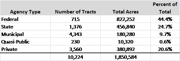
The most current data from GRANIT for conservation and public lands shows that 1,850,584 acres of land are in public ownership or permanently protected. This amounts to 32.3% of the state’s land area, and a gain of nearly 590,000 acres of protected land since 1996 when records were first systematically developed. Agencies and organizations responsible for conservation land in N.H. are grouped into five broad categories, as follows:
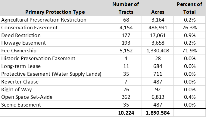
There are twelve types of protected land in N.H., some of which are not permanent or otherwise outdated (leases, deed restrictions, reverter clauses). More than 98% of conservation land is in fee ownership or conservation easement. See table on the next page with a breakdown of area and percentage of total for each type of protected land.
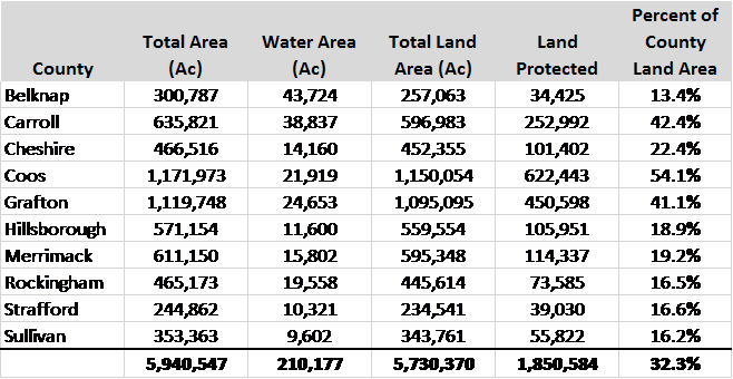
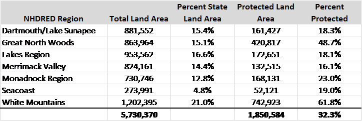
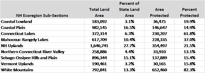
The extent and distribution of conserved land in New Hampshire has been grouped into four classifications: by county, by DRED tourism region, by regional planning commission service area, and by ecoregion. The data highlight that the extent and distribution of conservation lands varies significantly across the state. Northern municipalities and counties along with areas of high elevation tend to have much higher rates of land conservation. More southerly regions and lower elevation zones have far less area in conservation ownership, even though those areas often have tremendous natural resource significance and are typically at greater risk of conversion.
See the following four tables on this page and the next for a summary of conserved land in each category.
Protection of Drinking Water Supplies
In 2012, there were 1,151 community wells serving approximately 608,000 residents; another 511 wells serve businesses, schools, industry, and a host of transient uses such a restaurants, motels, ski areas, and campgrounds, with a population served of more than 128,000. This means that about 46% of the state’s population and most of our places of employment rely on public drinking water supplies.
Four resource features have been evaluated in order to determine the protection status of drinking water supplies in New Hampshire: sand and gravel aquifers (groundwater), remaining future site for potential groundwater wells, and both wellhead and source water protection areas defined by NHDES.
Aquifers
Sand and gravel aquifers are the primary source of community drinking water for one-third of municipal and other public water supplies (wells) in New Hampshire, and serve more than 600,000 persons statewide, or about 46% of the state’s population. Aquifers cover about 14% of the state’s land area, and are slightly more than 14% protected. At present, nearly 24 % of aquifer land area is currently developed with roads and urban/suburban land uses.
Favorable Sites for Future Wells
NHDES has mapped the areas of the state’s aquifers which are not impacted by potential contamination sources, and are the most likely locations for future municipal water supply wells pending more detailed hydro-geological investigation. These areas represent less than 1% of the state’s land area, and are currently only 23% protected.
Wellhead Protection Areas
NHDES has delineated hydrological-based protection areas around community wells and surface water intakes at drinking water reservoirs. These protective areas represent somewhat more than 5% of the state’s land area, and are less than 16% protected at present. A little more than 19% of these areas are already developed with roads and other land uses, and no regulatory mandate exists to require further protection of these lands.
Source Water Protection Areas
NHDES had also delineated certain watersheds deemed critical to maintaining water quality within community drinking water supplies. These areas amount to somewhat more than 7% of the state land area, and are slightly more than 45% protected. Although most of these watersheds are rural, about 7% of their area is currently developed.
Farmland Protection
The status of farmland protection in New Hampshire can be estimated using two sources of data: highly productive agricultural soils and currently active farming based on land cover information for cropland and hay/pasture utilization.
Highly Productive Agricultural Soils
The most productive soils in N.H. are defined by NRCS soils mapping in two classes: prime agricultural soils and soils of statewide importance. Together, the two soils groups total somewhat less than 7% of the state land area, and are approximately 12% protected. These soils are about 20% developed currently, and unavailable for farming.
Actively Farmed Land
Land cover data released in 2010 shows two levels of farming: actively cropped land and orchards, and open land maintained for hay or pasture. Statewide, these two classes represent about 4% of the state’s land area, of which nearly 13% is protected.
Forest Protection
Forest Blocks
Intact forest blocks greater than 500 acres in size, regardless of land ownership pattern, provide important water quality, wildlife habitat, as well as remote recreational opportunities, as well as the threshold for long-term economic forest management. Forest blocks greater than 500 acres account for two-thirds of the land cover in New Hampshire, and are currently about 40% conserved, although blocks in the lower size ranges close to urban centers are less well conserved (18% for blocks 500 to 5,000 acres).
Forest blocks greater than 5,000 acres represent an important threshold of ecological significance in term of maintaining the structure, function, and processes of local and regional ecosystems. These blocks total more than 2.3 million acres statewide, and are currently about 57% protected. Blocks in the range of 5,000 to 10,000 acres, which are important for ecological linkages among larger blocks, are only about 27% protected.
Prime Forest Soils
The most productive forest soils in New Hampshire total more than 3.8 million acres, or about 60% of the state’s land area, and are currently about 22% protected. However, the group of forest soils that represents the state’s best high-volume white pine growing land totals only about 11% of the these soils, and is only 14% protected at present.
Habitat Protection
The status of fish and wildlife habitat conservation has been assessed in several ways:
- Protection of broad eco-regions;
- NH Wildlife Action Plan data on habitat quality (terrestrial and aquatic habitats combined;
- NH Wildlife Action Plan data on aquatic habitat quality;
- NH Wildlife Action Plan habitat types;
- Rare species occurrences
- Extent of wetlands protection;
- Extent of floodplain protection; and,
- Habitat conserved by elevation.
Habitat Quality
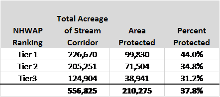
The NH Wildlife Action Plan (NHWAP) data update released in 2010 ranks habitat quality statewide in three tiers: Tier 1 is best in state, Tier 2 is best in ecoregion, and Tier 3 are supporting landscapes that work as buffers to protect the integrity of the higher two tiers. Taken together, the three tiers total to slightly more than 2/3 of the state land area. Protection status for each tier is as follows:

Aquatic Habitat
The NHWAP has developed data on the highest quality aquatic habitats, which include certain watershed-related stream networks as well as lakes and ponds that rated highly for habitat quality and ecological intactness.
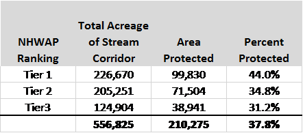
The stream networks are ranked in three tiers similar to the habitat quality tiers above, with Tier 1 representing the top 15% in quality statewide (by watershed group), Tier 2 is ranked in the top 30%, and Tier 3 are streams with occurrences of selected aquatic species of concern. Each watercourse is buffered by 100 meters (328’) to form a protective corridor along its length. Statewide and taken together, these corridors cover about 10% of the state, and are nearly 38% protected. Of 327 watersheds statewide, only 99 contain Tier 1 or 2 ranked watercourses.
The protection status for the NHWAP aquatic habitat tier rankings is as follows:
Rare Species Occurrences
The New Hampshire Natural Heritage Bureau maintains a database documenting over 4,000 distinct occurrences of rare plant and animal species in New Hampshire. Approximately 37% of these occurrences are found on permanently protected or public land, while 63% remain unprotected.
Top-Ranked Lakes and Ponds
As part of the NHWAP, lakes and ponds in New Hampshire were evaluated for habitat quality and ecological integrity. The top 10 water bodies in each of ten watershed groups were selected based on size, depth, and acidity, and a 200’ protective buffer was established around each water body which is critical to maintaining water and habitat quality. Land cover data was used to estimate the amount of land associated with the buffer that is already developed.
The total area of the top-ranked lake/pond buffer is about 14,770 acres statewide, of which 28% is currently protected. About 28% of the buffer is estimated to be developed by roads and other land uses.
Wetlands
Wetlands data has been generated using NRCS data for hydric soils – poorly and very poorly drained soils which are typically classified as wetlands, and include forested as well as marsh, bog, and shrubby types of wetlands, in combination with National Wetlands Inventory on wetlands types in the state.
The total area of hydric soils and mapped wetlands in N.H. is nearly 772,000 acres, or about 13.5% of the state land area. These wetlands are currently slightly under 25% protected.
Floodplains and Riparian Areas
Floodplains: Just over 6% of the state is mapped as 100-year floodplain by FEMA (note: FEMA mapping is not available for Belknap county), of which 21% is protected or in public ownership. Of the 79% of unprotected floodplains, 7% is developed and 6% is agricultural.
Riparian areas: Riparian areas cover approximately 28% of the state’s land area (not including open water), of which 30% is protected or in public ownership. Of the 70% unprotected riparian areas, 12% is developed and 5% is agricultural.
Elevation
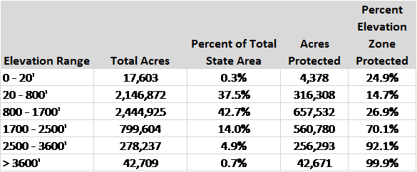
Elevation and terrain have a distinct correlation to various habitat types. The elevation classes in the table below are based on studies of ecological systems in New Hampshire by The Nature Conservancy. Higher elevations are typically better conserved, largely due to the historic emphasis on conserving peaks and scenic places in more mountainous areas. The lower terrain (20’ – 800’) in southeastern N.H. is the least protected, and the most densely populated and developed region of the state.
Recreation Opportunities
Public Access
Coding with regard to public access on conserved lands in the GRANIT conservation and public lands database indicates that slightly more than 70% of conserved tracts allow public access for hunting, fishing, and recreation. Another 2% restrict public access in some manner or at certain times. However, almost 26% of records in the database represent public access as unknown, so it is probable that many more tracts allow public access.
The distribution of conserved land has been analyzed for convenient accessibility from the most populated municipalities in New Hampshire (communities of 10,000 or greater). Nearly 20% of all conserved land is within a 20-minute drive time of 718,000 persons, or about 54% of the state’s population. Of communities greater than 20,000 persons (38% of the state’s population), about 10% of conserved land is closely located.
Regional Recreation Trails
Current data on local and regional recreation trails (hiking, biking, etc.) has mapped nearly 2,700 miles of trails statewide, of which about 82% lie on conserved land. Rail trails along abandoned railroad rights-of-way amount to about 443 miles of long-distance recreation opportunity, but are only 30% protected. Privately maintained long-distance hiking trails (Monadnock-Sunapee Greenway, Sunapee-Ragged-Kearsarge Greenway, and the Monadnock-Metacomet Trail) total about 150 miles, and are 52% protected at present.
NH Land Conservation Commission Full Report
Click below to read the full report of the NH Land Conservation Commission.
