
We're Number Two!
- Tags:
- Working Forests,
- Nature's View
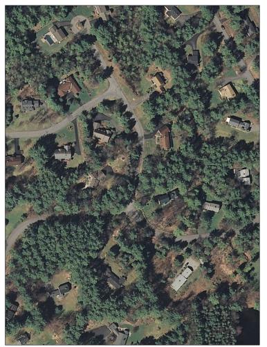
Forest cover may overlie an understory of homes. Suburban and exurban forests - this one near Keene, NH - provide example of where tree cover is misleading?
It appears we still don’t always see the forest for the trees.
Most people were duped by a flurry of media attention last summer erroneously reporting that New Hampshire surpassed Maine for having the highest percentage of state land area classified as “forest” in the nation. As a result, these same people are now righteously indignant when I tell them “sorry, we remain number two.”
Let’s set the record straight.
A USDA Northern Forest research study led by Dave Nowak of Syracuse University did indeed determine New Hampshire’s tree cover is 89 percent - higher overall than Maine’s tree cover estimate of 83 percent. Yet Maine still has more overall forest land. Maine is 89 percent forested compared to New Hampshire, which remains 84.9 percent forest land, according to Randall Morin of the USDA Forest Service’s continuous Forest Inventory and Analysis program (FIA). According to Morin, the FIA program measures land use every five years in New England inventorying 20 percent of each state’s land area per year. The Syracuse study measured actual existing tree cover. Thus Maine has areas of regenerating timberland classified as forest by FIA that would not have been counted in the tree cover study.
FIA defines forest land as land at least 10 percent stocked by forest trees of any size, or land formerly having such tree cover, and not currently developed for non-forest uses. The minimum area for classification as forest land is one acre.
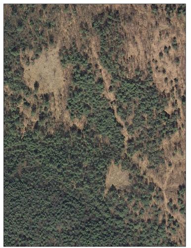
Statistical differences are more than mere semantics. There are fundamental ecological differences between areas under tree cover and those that are truly forested.
To understand the ecological distinction, consider the features of a forest understory. Forest soils, hydrology, water infiltration, flood attenuation, biological diversity and wildlife habitat diversity of forests all differ significantly from those in an understory beneath backyard trees or in shopping center beauty strips. The higher percentage of tree cover potentially includes homes, lawns, gardens, picnic tables, and edges of ball fields, golf courses, parking lots or other woodland fringes. Tree cover may not necessarily provide a wide range of tree age classes, sizes and species composition including standing dead “snag” trees and downed, rotting logs. It’s also true that a vast interconnected microscopic wilderness of mycorrhizal fungi only thrive in specific forest soils in intimate associations with particular tree species and moisture regimes not well-represented beneath “tree cover.” Habitats required by forest specialists like pileated woodpeckers and spotted salamanders are more complex and nuanced than those utilized by grackles and gray squirrels for which trees alone provide sufficient habitat.
It’s understandable that people -- journalists included -- assume the aerial estimate of “tree cover” is synonymous with “forest cover.” But this classic “apples to oranges” comparison ignores forest ecosystem services and complex habitat associations not found in suburban backyards and urban fringes.
It’s also true that there are New Hampshire residents who would love to claim the superlative distinction held by Maine for having the most forested state. Yet our 89percent aerial “tree cover” estimate doesn’t qualify us to wear the most-forested crown.
When it comes to forest land, at 84.9 percent we are still second to Maine’s 89percent forested status. It gives us something to aspire to!